Ninety-seven percent of North Atlantic cyclones form after June 1st and before November 30th. Note that the end of the Atlantic hurricane season used to be October 31st, but it was moved because the hurricane scientist got tired of cleaning out their locker six times a year instead of just one time. Over the many years of tracking storms, 89 named storms have happened outside the named season.
So it is not utterly odd that Tropical Storm Andrea is now swirling about in the Atlantic, southwest of Bermuda.
It is possible, but unlikely, that Andrea will turn into a hurricane. It is too early to be sure bla bla bla but all the available information about this storm strongly indicates that it will move up the middle of the Atlantic and eventually become a large wet spot somewhere in Europe. I’m putting my money on Ireland. (yes, I now, too early bla bla bla, but Ireland.)
For your information, the next named storm will be Barry. Then…
Chantal
Dorian
Erin
Fernand
Gabrielle
Humberto
Imelda
Jerry
Karen
Lorenzo
Melissa
Nestor
Olga
Pablo
Rebekah
Sebastien
Tanya
Van
Wendy
Minnesota established its national reputation as a snowy and cold state because of a series of real and fictional events. During this time, the population of Minnesota has grown considerably. I’ll tell you why this matters after I show you the important data. We will then use this new found understanding to evaluate a recent viral video in the light of changing climate.
1970 Blizzard episode of Mary Tyler Moore show (no casualties). Population: 3.8 million
1991, Halloween Blizzard (22 dead, 100 injured). Population: 4.3 million
2019 The Great Snows of 2019 (casualties not yet counted). Population: 5.7 million
The average total snowfall for the Twin Cities is 47 inches over the winter, over the last century or so. Prior to 1979 (inclusively) the average was 43.7 inches. After that date, the average has been 53.4 inches. That is an expected increase of 20% owing likely to added moisture in the atmosphere caused by global warming.
For comparison, the average total snowfall in Buffalo, New York is 94 inches. The average annual snowfall in Boston is 42 inches, more like Minnesota. It is said that Minnesota gets a lot of snow. But really, Minnesota is mostly a semi-dry state, where agriculture only happens with irrigation, and the snowfall is half what it is on the other side of the Great Lakes, and about the same as the east coast. (The east coast is wetter, but more of that falls as rain or, as is the case of Boston, dense slush.)
Since the famous Armistice Day blizzard, which surely contributed significantly to Minnesota’s reputation, the population of the state has doubled. Since the Mary Tyler Moore days, when Minnesota became known to most other Americans, population has gone up by something like 30%. Indigenous Minnesotans don’t reproduce that fast, and many move away (to California, mostly) so that is a much larger number that are totally new to the area, often from tropical or at least warmer, areas, than one might think.
Plus, Minnesotans are known to be masters of passive-aggressive. But this also means they are masters of another trait: Deep denial.
For all these reasons, the weather of Minnesota matters little, and the reputation not at all, as a foundation for the ability of Minnesotans to handle winter. Which brings us to the following video, which YOU MUST WATCH TO THE END:
Conclusions: Look out the window before you leave your garage!
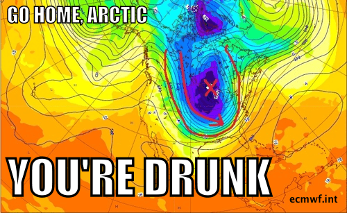
Dusting off the old meme I made a few years back, last time the Polar Vortex attacked North America:
And yes, regardless of any dispute about the term “Polar Vortex” itself (there is some confusion and disagreement), the excursion of air masses that normally reside in a particular latitudinal region (i.e, tropical, temperate, polar) can be, and likely is, caused by the effects of human release of greenhouse gasses. Ironically, the sequence of steps that go from your local coal plant or the back end of your excessively large car to an attack by the polar vortex involves a warming of the Arctic. So, I suppose, the polar air we are at present being assaulted with could be worse.
Simply put, as the Arctic warms, the age-old and somewhat complex process of heat moving from the warm equatorial regions to the poles (which you know it has to do, right?) is messed up because the longitudinal temperature gradient is messed up. This causes the giant circles of fast air known as the jet streams to bunch up and form enormous semi-stable loops known as quais-resonant Rossby waves. Once these suckers are happening, all kinds of things happen, like very wet rainy periods causing major flooding, much larger and more intense than usual blizzards, multi-year droughts, and these very annoying arctic incursions.
And that’s what we are having right now in the upper middle part of North America.
Like this:
Note that when you get down that far, the difference between F and C matters little.
1) Over 500 people died in Paradise, who’s bodies have not yet been recovered.
2) Over 500 people fled Paradise, and now, getting on to weeks later in time, have not heard that hundreds are missing and unaccounted for, and that hundreds of searchers are looking for them in the rubble, with no small amount of danger to the searchers, anxiety to everyone else, and of course expense. Continue reading Lost in Paradise, California→
Seriously? A hurricane heading to Texas, you say? How can that be, the Atlantic Ocean is devoid of any significant storm activity that could possibly lead to a hurricane.
Turn around! Hurricane Willa is churning off the West Coast of Mexico, and is expected to develop into a major hurricane before hitting the Mexican coast. It will then traverse the wide part of Mexico and eventually, as a tropical depression, arrive in southern Texas. So, technically, a hurricane, is not going to hit Texas. But Hurricane Willa, it its latter days as a potentially newsworthy storm, will. And it will be wet and flooding will likely be a concern.
Also, keep an eye out for what this tropical depression does if it actually breaks through to the Gulf of Mexico. It is too early to say, but there are projections that have Wil;a’s remnants staying on the mainland and wetting down Texas, Louisiana, Mississippi, then maybe Alabama, Tennessee and points further north. There are projections that have it go out to the Gulf, and then, in some case, hitting florida. Of the many models out there, only one, however, has the storm actually gaining sufficient strength over the Gulf to become a hurricane again. But still, keep an eye out.
Wil;a will probably transition into a strong Category 3 hurricane by mid day Monday. About Mid day Tuesday, the storm will be far off shore, but its forward speed will increase dramatically and it will be a very fast moving hurricane, making landfall by mid day Wednesday. The first wet spots from Wil;a will be coming into Texas by mid day Thursday.
The storm is expected to come ashore anywhere between LaCruz and Tepic, with the current bulls eye being around Escuinapa on the coast, Durango inland. At risk is a fairly intensely developed agricultural region along the coastal plain. The storm will pass over very hilly and mountainous terrain, which presumably creates a large risk for flooding. The area of Texas most likely to be affected are south of (and including) San Antonio and Austin, all the way south to Brownsville. However, it is a bit early to make such predictions.
A little after Willa plows into Mexico, a second storm, Vicente, not expected to become a hurricane, will menace roughly the same area along the Mexican coast.
Just a quick note to inform those of you who get all your news here, that Hurricane Michael strengthened to a Category 4 storm, and will be a Category 4 storm at the time of landfall today, wed, mid day or early afternoon. I’m asking around to see if storm experts see that as truly unexpected or in the range of normal variation. My bet: Deep warm surface waters (to 100 meters or so) at “hurricane level” temperatures fueling the storm. That happened with Katrina, Maria, Pacific Yolanda, other storms. Just a guess on my part for now.
The storm is actually continuing to get stronger, but will remain in the Category 4 range.
Maximum sustained winds, therefore, will be ca 140-145 mph, which is equivalent to and F-2 tornado,but the size of Rhode Island.
In addition, note that this storm is now predicted to remain as a Hurricane way inland, and may be a Category 1 storm past Albany, Georgia.
In short, Michael will be one of the most impressive hurricanes to ever make landfall in the Atlantic US. And just think only a few days ago, we had no idea it was coming. My friend Paul Douglas just confirmed for me that a Category 4 hurricane has never hit the panhandle of Florida.
One tiny piece of good news. The storm is making a rightward turn, just a small one, and the bulls eye has held steady or moved slightly west. This has the effect of reducing the strength of the storm surge east of Apalachicola. A little.
I would not want to be a barrier island or estuary anywhere near Port St. Joe this afternoon.
Atlantic Hurricane Michael will be a memorable, destructive, storm. It is currently about 250 miles south of Florida, and will likely hit the Florida Panhandle the hardest, but nearby areas are at risk. As I write this, the storm is moving north with 105 kt (120 mph) winds. That makes it a stoong Category 3, aka major, hurricane.
Tuesday/Wednesday Midnight
During the wee hours of the morning, Michael will be a Category 3 storm, with winds of about 110 kt (125 mph) but with maximum gusts of 135 kt (155 mph). Tropical storm force winds will be arriving along coast, anywhere from Louisiana to the entire Gulf Coast of Florida.
Wednesday Morning
By sunrise tomorrow morning, Michael will have strengthened somewhat (winds at 110 kt, 125 mph). I’m not sure if Michael will beat any records, but it will go on the short list for how little time it take to go from a tropical disturbance to a major hurricane, and how little time it takes to go from a recognized threat to a land-falling storm. Michael may challenge our process of preparation and evacuation.
Wednesday mid day
The eye of Michael will be looming off shore by mid afternoon tomorrow, making landfall before dinner. Just at the time of landfall, the storm will be a stgrong category 3, with 110 kt (125 mph) winds, with gusts of 135 kt (155 mph).
But long before landfall, the storm will be pelting coastal and inland communities, because “landfall” isn’t the key moment in a hurricane’s life. (See this for more on that.)
Bulls Eye
The bulls eye of the storm, the middle of the range across which predictions say the eye will make landfall, has only moved a little over the last day or so. However, remember that as storms move off the ocean and onto the continent, their track can become less predictable. However, in this case, most of the different tracks predicted by the various models are similar. Also, it is my impression that Gulf storms going north at an accelerated speed into this area tend to stay on track. So, it is very reasonable at this point to suggest the following are very likely:
The center of the storm the eye, will make landfall somewhere east of Pensacola, which is at the western tip of the Florida Panhandle, through somewhere east of Tallahassee. In other words, almost all of the Florida Panhandle is in or very near the most likely spot for landfall. The exact bulls eye a this moment is ther Tyndall Air Force Base, in the immediate vicinity of Panama City Beach.
If this storm puts its eye over Panama City, would somebody please get a picture of the Hard Rock Cave sign inside the eye? I’m actually writing a piece of fiction where that exact photograph is used to make a “Welcome to Florida” post card that figures into the story. Thanks.
Anyway, of extreme relevance is this. There is about a 50-50 chance, or a little less, that the eye will come to shore in such a location that the hard-bunch front right quadrant of the storm will hit the coast at one of the worst possible places to do so in the Gulf. The front right quadrant of a fast forward moving Atlantic hurricane is where maximum damage tends to happen. There are three reasons.
1) A storm with 100 mph wind swirling around the center, but moving forward at 20 mph, can have 120 mph winds in the front right quadrant.
2) All the things that cause a storm surge are maximized in the front right quadrant of an Atlantic hurricane.
3) Even the rainfall is probably greater in the front right quadrant, because this is the part of the hurricane where the corpus of the storm has spent the most time over warm sea water, picking up moisture.
Now we add the coastal effect. When a storm surge moves against the coast, if the coast itself is funnel shaped, or embayed, the surge is narrowed down and concentrated.
If the eye of Michael comes ashore near Apalachicola or to the east a bit, the right front quadrant would be facing into a bight, the embayed area that forms part of the armpit of Florida. Within that bight, at a much smaller scale, are numerous estuaries that run perpendicular to the coast without a lot of barrier island protecting them. There is a very large area where the National Weather Service, which by the way the Trump Appointed Secretary of Commerce (NOAA is within the Commerce Department), who also owns a private weather company, wants to essentially shut down, estimates possible storm surge of over 9 feet. Like this:
Inland, the storm will move quickly north and east, and by the end of the week, tropical storm force winds will be up in the Canadian Maritimes. Within 24 hours of landfall, the wet and windy remnants of Michael will be menacing the region previously flooded by Florence. The storm will probably punch back out into the Atlantic in coastal Virginia or North Carolina.
Hurricane Michael just formed in the straits between the Yucatan and western Cuba, and it is heading for the US Gulf. The bull’s eye is currently the vicinity of Port St Joseph and Apalachiocola, not far east of Panama City. The right front quadrant thus is heading for the bight between Apalachicola and Suwannee, where things could be very messy if there is a strong storm tide.
Landfall would be expected in about 48 hours, and the actual bull’s ey could be anywhere between Pensacola and Cedar Key, with areas well outside of that (including Mobile, Alabama) being affected.
The thing about this storm is that just a few hours ago, it was projected to be a Category 1 storm, but is now expected to be a (weak?) Category 3 storm. And, it is coming in fast.
It is too early to say what the storm surges may be, or exactly where it will come ashore. Unlike Florence (or Harvey), Michael is not expected to linger on or near the coast, but rather, will plow through the US Southeast as a storm, probably passing over Atlanta, coming into the Atlantic not far from where Florence went, possibly menacing Washington DC and Philadelphia, the home of the Eagles, recently defeated by the Minnesota Vikings. There could be areas with 6-10 inches of rain in the Florida Panhandle and Georgia.
The two big climate change related stories with Michael may end up being: 1) It formed fast and got strong fast and moved fast, like Patricia (Mexico, a few years ago) and Maria (2017); and 2) Michael is passing over anthropogentic-climate-change-superheated waters (at least somewhat superheated) in the Gulf.
Faced with Hurricane Florence’s powerful winds and record rainfall, North Carolina’s solar farms held up with only minimal damage while other parts of the electricity system failed, an outcome that solar advocates hope will help to steer the broader energy debate….
When Florence made landfall on Sept. 14, it caused power outages across the region. As energy experts point out, the most vulnerable part of the system is not new at all: it’s the power lines and other equipment that transport electricity to customers.
Rooftop solar did ok as well.
Rooftop solar companies, such as Renu Energy Solutions in Charlotte, say there was little damage to their customers’ home solar systems. However, installers in some of the hardest-hit areas, such as Cape Fear, did not respond to messages seeking comment and there is a higher likelihood of damage there.
So, we’ll see how that goes, but I imagine the biggest problem for rooftop solar is a tree falling on the house, and when that happens, the home owner may have a bigger problem than some solar panels getting smashed.
My first thought on hearing of the outbreak of fires and explosions in Lawrence and Andover Mass was to wonder how many people living in or near these homes are having PTSD reactions right now. You may not remember this, or even know about it, but back in 1991 and 1992, when I was working in Lawrence and Andover and other New England locations doing archaeology, there was an amazing spate of arson attacks in the area. There were over 200 fires set in the city, many of old historic mills that burned to the ground. The people of Lawrence were truly traumatized by this. The cops arrested two people and charged them with several counts, but I don’t think they were ever determined to have been responsible. I don’t recall this spate of crimes ever being solved.
My second thought was, could this be the energy infrastructure Russian FSB/GRU attack that we were warned of?
It seemed early on that the gas fires in Lawrence were caused by large increase in pressure on the gas lines. The pressure in the gas lines going into your house is set to be just above atmospheric pressure, while the pressure in gas delivery lines can be very much higher. There are devices that down regulate the pressure as it gets nearer your house, and the lines in your neighborhood that feed individual buildings have the lower pressure. The main natural gas “transmission” lines have sensors that measure pressure, and computer systems that regulate pressure. There have been cases in the past (not necessarily in the US) where malicious code was used to blow up gas lines by changing the pressure. Interestingly, an instance of computers going wrong (which may or may not have been a cyber attack) caused the largest non-nuclear explosion ever, on the Trans-Siberian pipeline.
Most likely the Lawrence gas explosion involved something going wrong with pressure, and most likely that was something wrong with a valve (or human error, or whatever). But, given that we (Americans) were warned that the energy infrastructure had already been hacked by Russian agents (not regular people who are Russians, but by bad guy Russians working for bad guy Putin) …. well, somebody really should look into that. Just to be sure.
It is never too soon to talk about human caused climate change in relation to hurricanes. This is a bed we made and we are now sleeping in it.
Rather than yammering on and on about how a warmer atmosphere is a damper, but also more evaporation-inducing (and thus drying), and energetic atmosphere, and about how warmer air going over warmer sea water produces more and bigger storms globally, and all that, I’ll point you to some resources below.
But first I want to address two misconceptions: 1) that you can never attribute to a particular storm the effects of climate change THIS IS FALSE and 2) that climate scientists believe that Atlantic hurricanes will become less and less of a problem with climate change THIS IS ALSO FALSE.
On the attribution. Let’s say there is a disease with a 50% mortality rate. But then a treatment is invented that reduces that to zero. We use the treatment widely and nobody dies of it any more. Then, you get the disease, are cured, and go on a public speaking tour in which you espouse the greatness of this cure.
But one night, while you are speaking in front of a large audience, someone stands up and says, “Hey, wait one darn minute there! You might have been one of the 50% that would have lived! You can’t say that this cure did ANYTHING. Faker!”
The audience, realizing that the cure does not actually work, stands up and walks out.
Was that fair? Was what just happened in this scenario a honest, thoughtful turn of events?
With climate change it is a little like that. People who want to deny the importance of climate change, including journalists still stuck in the false balance mode (if there are Senators in the Senate claiming that human caused global warming is a hoax, then we must consider that as equally likely as what all the world’s scientists are saying), pull the attribution rabbit out of the hat all the time. Since you can’t yada yada. Even some climate scientists used to say this because the were badly trained in what to say.
Indeed, the binary (cure/not cured) I gave you above is not really like climate change. The fact that ALL the sea surfaces in the tropics and sub tropics — every single square centimeter — are on average (and in fact most of the time, for most of the seconds of most of the days, all year) anomalously warm, all of the tropical weather systems are affected all of the time. Fail to understand that at your peril.
The second falsehood, that Atlantic hurricanes will become less of a problem, is perhaps even more pernicious. There once was a study that seemed to show that some of the climatic conditions that would attenuate tropical cyclones, denying them the chance to form into hurricanes, would become more common in the Atlantic. This is probably true. However, the climatic conditions that cause tropical storms to form and advance to hurricane stage are also increased — different effects — and these effects have the added bonus of causing hurricanes to form much more rapidly and sometimes (perhaps often) grow much larger and, by the way, exist farther north. Indeed, if Florence does reach Category 5 for a short time today or tomorrow, it will be the farthest north Cat 5 hurricane ever in the Atlantic.
Here’s the thing. We will see periods of time when hurricanes that might have formed, say, 20 years ago, won’t. But we will also see periods of time when more and bigger and worser hurricanes form. The actual average number of hurricanes in the Atlantic has not gone down, but rather, stayed fairly stable, over recent decades. The frequency of large and dangerous hurricanes globally has gone up, and that trend is probably observable in the Atlantic.
Point is, we are not seeing a decrease in Atlantic hurricane activity or impressiveness, and we are seeing records being broken with respect to time to formation, size, strength, etc.
Climate Signals has a page on Hurricane Florence. They point out that sea level rise and coastal storms are a significant coastal erosion threat. warmer waters make for more and bigger hurricanes, keeping the hurricanes big longer, and making them form faster. These hurricanes are wetter.
Indeed, we have replaced the term “Biblical Flooding” with “Harvey Size Flooding” since we no longer have to imagine it.
Here is a helpful video:
This graph showing the relationship between sea surface temperature and hurricane activity.
Remember all those details about exactly what Atlantic Hurricane Florence was going to do later this week? Well, the plan has changed in important ways. Mainly, the inland effects will be stronger, more to the south, and more concentrated in space. Read below for details. Continue reading Florence: Change in plan→
Hurricane Florence has strengthened as expected. There will likely be some more strengthening, followed by some weakening near the coast. Florence will remain a major and deadly hurricane until after landfall, and then, it will be a deadly flood causing storm with significant winds.
Timing
The best estimate for timing of events is as follows.
On Wednesday morning, Hurricane Florence will likely be looming just off the Carolina coast, with winds of about 140 mph (making it a Category 4 Hurricane).
Tropical storm strength winds will come ashore Wednesday night. Strong surf will have already developed.
The strongest part of Florence will be pounding the Carolina coast at sunup on Friday, and the storm may sit right on the coast for several hours as it winds down to a tropical storm. Landfall and this rapid weakening may happen at about the same time. It is remotely possible that the eye wall will not pass over the coast, thus causing weather reporters and climate disaster deniers to become stupified.
Storm surge
It is important to understand how storm surge warnings work. There are two kinds of estimates that can be made. One is to assume exactly where the eye will come ashore, exactly when (to include the contribution of tieds), estimate the wind speed and forward speed of the storm, and the angle of movement, then use all these variable together with the topography of the coast to estimate how high flooding will be at any given point.
The second is to look at where the storm may go, and how strong it might be, and how those other variables will pan out, but with uncertainty in location and timing being much larger, and produce a map of coastal regions indicating where there might be high flooding, and how high that might be.
The former is generally not what you are looking at when you see a storm surge map. For example, right now there are estimated storm surges of over 9 feet near Kinston and Greenfille North Carolina, but only one foot in and around Albermarle sound. This is based on a combination of the likely track and behavior of the storm but considering that we don’t know exactly where the storm is going to hit. The difference between Greenville and Albermarle sound is a combination of where we think the storm is going and what the storm might do. The two topographies are greatly different, accounting for most of the difference in possible flood height.
In other words, most of the flood levels indicated in most storm surge maps are not going to happen. Only some of them. But, we don’t know which ones.
Anyway, there are storm surges expected to be greater than 9 feet in some places. Even three foot surges are a lot if it is high tide along very low lying barrier islands. If Florence does plow into North Carolina as expected, it is quite likely that the configuration of the barrier islands along that coast will change. Some lines may become dotted lines. Some inlets may be filled, some new inlets created, many tidal channels in the estuaries will shift. Places like the town of Ocracoke may suffer very sever damage, as they lie below the maximum possible food surge.
Flooding
Aside from storm surge, flooding happens inland with hurricanes. The special feature of East Coast hurricanes, especially in “Hurricane Alley”, between Northern Georgia and southern Virginia, is that behind the coastal plain there is a mountain range. So, if tropical storm carried water dumps on that mountain range, a two or three inch rainfall over a very large area can cause significant flooding.
Rainfall of over four inches is expected to fall over most of Virginia, and about half of North Carolina. Delaware, DC, Delmarva, Maryland, southern Pennsylvania, and parts of West Virginia and South Carolina will also get lots of rain. The area of expected landfall, and a few areas in land (like in south-Central Virginia) may see rainfall totals of over 15 inches, maybe two feet right along the coast.
A lot of roads and bridges will be wiped out, immortal doods in large pickups will be obviated, and low lying villages will be flooded. Unless the storm does a zany (and very unlikely) turn to the north before coming ashore, this may be the biggest problem, since it is hard to evacuate five or six states.
Washington DC could get up to a foot of rain. Note: The White House lies on much lower terrain than the Capitol. I’m not promising you a Rose Garden flood, but it could happen.
What if
Florence is just like any other storm of the day: Enhanced by global warming. But note this. Florence will weaken from a strong Category 4 storm to a strong Category 3 storm as it gets near the coast. This will happen because the warm waters on the surface will be churned by the storm itself into the colder water at depth, weakening the storm. Over recent years, however, we’ve seen storms fail to weaken, or even strengthen when they would normally have weakened, because the deeper water is still at “hurricane-strength” temperature. Katrina, Haiyan, and some of last year’s Atlantic storms exhibited this behavior.
With increased warming of the sea, this will eventually start to happen in the US East Coast littoral. Florence ten or twenty years from now would build to Category 5 strength and keep that level of intensity, or nearly, before reaching the shore. And, in ten or twenty years from now, sea levels will be higher. And, by then, a few other hurricanes would have smashed up the barrier islands. In 20 years, North Carolina and Virginia are not likely to be very well protected by those sand features. James Hansen was right.